truck sat nav

This is seriously doing my noggin in now :Angry: Went on the Freemapsupdate site, put in the I.D. etc, clicked on update UK maps on Truck option which downloads 3 files, all the files are named UNITED KINGDOM_R3_TOMTOM 2013.0 one's an FBL file, 117,379 KB, ones an FSP file 25,301 KB and the last is an FTR file 9,524 KB. What am I supposed to do with these ?
Also when I plug the satnav into the usb on the pc, the satnav screen just shows an image of a usb plug with three dots scrolling along the bottom, can't do any touch screen stuff on it and when I unplug it, the satnav shuts down. Not sure which screen to put my foot through first, the sat nav or the p.c. :Angry:

Edit. OK just gone through Paul's setup for the download which I should have looked at first and I'll try that after I've been for a walk round the block ! Why is computer stuff so difficult, all I want to do is erase one file and replace it with another ?
 
Last edited:
I was looking at the download website to see what maps they now had on it and the maps have changed from NQ (navtech) to what appears to be TomTom. However there are not so many files for each country and there are no poi or phonetics country files. I would be interested to see the file structure of a new unit to see if they have completely changed the satnav software.

I don't know if these new map files are compatible with the older units and whether you have to download completely new software for them.

Has anyone got a new navibuzz Noza Tec unit that they could post the file directory structure from. (screen dumps from pc)

John
 
Last edited:
Having spent many years working in IT I don't normally find computers difficult.

I would not have found the sat nav anywhere as easy to use, though, without the input from Lunarman, Trikeman, Pwilmo and all others who have contributed help on this thread.

Thanks all :thumb:
 
Last edited:
After a fright with the order Just the free cig lighter arriving and nothing else.
My unit has arrived two days later.
It says on the paper work latest maps are updated already:Doh:
Q.1 Are they?/
I shall find time to answer that question myself using the first class guide downloaded from
Paul "pwilmo" Excellent work Paul :thumb:you could get a full time job in China

PS Do you fancy re writing the MoT manual for me??:Wink:
Geo

Exactly the same thing happened to me, got the cigarrette lighter adaptor then nothing for 3 days. Mine said the maps were the latest too, till I tried using it.
Any way, here we go for round 3 !

Subscribers  do not see these advertisements

 
Has anyone got a new navibuzz Noza Tec unit that they could post the file directory structure from. (screen dumps from pc)

John[/QUOTE]

I'd love to help but I couldn't find my arse with both hands at the moment, never mind do a screen shot :Laughing:
 
This is seriously doing my noggin in now :Angry: Went on the Freemapsupdate site, put in the I.D. etc, clicked on update UK maps on Truck option which downloads 3 files, all the files are named UNITED KINGDOM_R3_TOMTOM 2013.0 one's an FBL file, 117,379 KB, ones an FSP file 25,301 KB and the last is an FTR file 9,524 KB. What am I supposed to do with these ?
Also when I plug the satnav into the usb on the pc, the satnav screen just shows an image of a usb plug with three dots scrolling along the bottom, can't do any touch screen stuff on it and when I unplug it, the satnav shuts down. Not sure which screen to put my foot through first, the sat nav or the p.c. :Angry:

Edit. OK just gone through Paul's setup for the download which I should have looked at first and I'll try that after I've been for a walk round the block ! Why is computer stuff so difficult, all I want to do is erase one file and replace it with another ?


Apart from that you like it? :Rofl1:

But seriously, I've got this to come. :Sad:
 
After a fright with the order Just the free cig lighter arriving and nothing else.
My unit has arrived two days later.
[HI]It says on the paper work latest maps are updated already:Doh:
Q.1 Are they?/[/HI]
I shall find time to answer that question myself using the first class guide downloaded from
Paul "pwilmo" Excellent work Paul :thumb:you could get a full time job in China

PS Do you fancy re writing the MoT manual for me??:Wink:
Geo

They are the latest available to the supplier, which is not the same as the absolute latest. Don't know why, just that it is the case.
 
I was looking at the download website to see what maps they now had on it and the maps have changed from NQ (navtech) to what appears to be TomTom. However there are not so many files for each country and there are no poi or phonetics country files. I would be interested to see the file structure of a new unit to see if they have completely changed the satnav software.

I don't know if these new map files are compatible with the older units and whether you have to download completely new software for them.

Has anyone got a new navibuzz Noza Tec unit that they could post the file directory structure from. (screen dumps from pc)

John
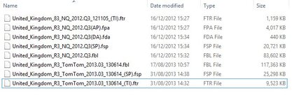
I haven't researched the different file types and what they mean but there is commonality to an extent between the maps (dated 16/12/2012) which were available when I bought my unit.

The screen shot attached shows the five UK files from that time and the three UK files unzipped from a download I executed a few minutes ago (they are in a folder I created on my PC).

I've no idea why there are three rather than five files in the new set but it is the file format, rather than the file name, which is important.

I suppose the only way to test if they work is to back up the existing set-up and then copy the new ones over.
 

Attachments

  • Image1.jpg
    Image1.jpg
    43.9 KB · Views: 29
I just found an explanation of the iGo file types Here.

FBL - Maps
FSP - Smart Route Profiles
FTR - Truck Restrictions
FPA - Address Points
FDA - Driver Alerts

On that basis I guess that the three files in the latest download are the essentials and the Address Points & Driver Alerts are extras. Again, though, I haven't researched it thoroughly.

Subscribers  do not see these advertisements

 
iGO 9 File Types

Here is some info on the files used on our Chinese satnavs.. As you can see; the footnote says - for warnings they must be of the same release date. I'm assuming probably version match aswell.
I'm going to email our nice little lady from the navbuzz to see what she has to say

fbl- Actual Map *\content\map\
fda- Warnings, Driver alerts *\content\map\
fpa- Proximity Alerts, Pointing address, Adress points *\content\map\
fsp- Speed profiles *\content\map\
ftr- Truck restrictions, Information for Trucks *\content\map\

kml- Custom Points of Interest *\content\userdata\poi\
bmp- POI Icons *\content\userdata\usericon\
poi- Points of Interest *\content\poi\
hnr- Programmed Routes *\content\map\
3dc- 3D Buildings *\content\building\
3dl- 3D Landmarks *\content\building\
hsp- Hstorical speed *\content\histspeed\
txt- Radars *\content\speedcam\
ph - Regional Voice Corrections, Reporting street names *\content\phoneme\
dem- Digital Elevation Model, represents the terrain surface *\content\dem\

fda= used in conjunction with Navteq maps (must be of the same release date) gives warnings like Railroad Crossing, Pedestrian Crossing, Slippery Road, etc--flashing the corresponding icon on the map screen--assuming such warnings are enabled.
 
Well I just received my Complete Idiot's Guide to a satnav from Pwilmo. I ve just taken a peek and downloaded and saved and it is currently printing.

By Jove the man's a genius. Straightaway I can see the wood for the trees just by having 2 or 3 minutes with it. I have checked an area i struggled with and now seen how i did it. I suppose I was better off for working some of it out myself, and I m not that much of an idiot on here, but this makes what I did seem like a piece of wee wee.

I am indebted.
 
Just been reading pwilmo,s guide. I can only assume he is not only a computer wizz kid but is he also fluent in translating Chinese.

Top man.
 
I gave up and got the missus to sort it out :cry: But she agreed there was no way she’d have managed with just the supplied instructions. Well done Paul, you’re owed a drink at least if our paths cross.
 
I have received Paul's manual and had a quick look at it and my initial thoughts are that this will be a great boon to my use of the sat nav. Thanks Paul for all your hard work. Plus I would like to thank Lunarman for his assistance in the past.

Subscribers  do not see these advertisements

 
Last edited:
Also just received the manual, Thanks Paul. brilliant, idiots guide to Truck sat nav. :thumb::thumb:
 
just read/looked through pwilmo's sat nav Complete Idiot's Guide and wow some thing's i had worked out wish i had this when i first got mine
a big:thumb::thumb::thumb: for pwilmo
Bill
 
Looking for a bit of help, I have just procured one of these Sat Nav's from a friendly forum member. However a couple of thing are confusing me, hopefully someone can point me the right direction!!

1) I am trying to set the Vehicle Profile. I am creating a new car profile but using the MH dimensions. The profile is clearly selected however the icon on the map is that of a taxi, also when I select other icons these do not appear correctly. I am wondering whether the dimensions I set are not being used to calculate the route because of the taxi icon?

2) Can I select my destination from a list of POI's, for example I have Archies Europe loaded. I would like to search the file by campsite name and select this as a destination, is this possible. If not what is the point of having the POI's loaded?

On the first point I am wondering whether to use the rest button on the back to resest the device, this may reset the navigation software however I am thinking it may also do a load of resetting I don't want.

All advice welcome, thanks
 
Well, we have used the satnav in anger for the first time today, didn’t realise we had so many 20 mph zones in town :Blush:. Well chuffed with it’s performance but it didn’t suggest doing a U turn when I drove past my destination, wanted me to go another 4 miles to a roundabout then come back. I’m sure someone else on here had the same problem, oh well, only 36 pages to read through again to find the answer :Doh:
Just as an aside, I pity any poor bugger who has bought one and doesn’t have access to a great resource like this site.
 
What vehicle profile were you using, I have read previously on the forum that you need to use a car profile. If you are using lorry it wont suggest u-turns.

Subscribers  do not see these advertisements

 
Well, we have used the satnav in anger for the first time today, didn’t realise we had so many 20 mph zones in town :Blush:. Well chuffed with it’s performance but it didn’t suggest doing a U turn when I drove past my destination, wanted me to go another 4 miles to a roundabout then come back. I’m sure someone else on here had the same problem, oh well, only 36 pages to read through again to find the answer.

I posted a comment pages ago stating the same problem. Unfortunately, I haven't found a solution yet.
 
What vehicle profile were you using, I have read previously on the forum that you need to use a car profile. If you are using lorry it wont suggest u-turns.

I definately put Busty's vital statistics in but maybe modified them in the lorry profile, will try again later in the car one, ta.
 
What vehicle profile were you using, I have read previously on the forum that you need to use a car profile. If you are using lorry it wont suggest u-turns.

Another "feature" I found some time ago (Broken Link Removed) is that using a truck profile it obeys truck weight limits rather than profile weights. Jock's explanation Broken Link Removed. I tried changing to a car profile but found it then routed me down a road I know to be unsuitable for large vehicles.

The thing is that all sat navs are a bit of a compromise. The way we use it is with a profile for our van based on a truck profile but also the navigator having the Phillips Truck atlas (or, in future having just bought it, the Phillips C&CC atlas) as a backup.
 
. Well chuffed with it’s performance but it didn’t suggest doing a U turn when I drove past my destination, wanted me to go another 4 miles to a roundabout then come back. I’m sure someone else on here had the same problem, oh well, only 36 pages to read through again to find the answer :Doh:
I've not got the unit right in front of me at the moment, (certainly not at this time of day :Laughing:), however, in the settings somewhere you can turn "on or off" the "Avoid U Turns" as I have done, otherwise it will take you to the next roundabout, however many miles away that is, which is great if you are driving a 44 tonne artic. :Wink:
Don't forget the "More" button at the bottom of some of the screen displays.

On the "weights" issue, after Lunarman's updating of my unit, I reset the Motorhome (Lorry/Truck) profile for a maximum weight of 7.52 tonnes, but with the actual weight at 4.5 tonnes. This resulted in the unit still taking me to my destination in Beverley (East Riding) but displaying screen warnings of 7.5 tonne weight limits ahead, (along with the audible "ding").
These screen warnings gave me the opportunity to either "Accept" (whereupon it would re route me), or "Dismiss", via on screen buttons. I did not find that facility either off putting, nor distracting. It does the same with low bridges.

BTW, compared to my TT720, I find this unit to be quick, ie, at 50/60mph, it's only takes between 2 -3 seconds from passing the speed warning signs, to receiving a verbal, as well as on screen warning. I remember counting up to 5 seconds when using the TomTom. :Sad:
I have set my speed warnings with no tolerance at all, so when doing 51mph in a 50mph zone, Kate is quick to tell me, and the screen shows an animated warning too. :Wink:
I may return to the TTS Voice at some stage, but prefer Kate's in the "Verbose" mode. :Wink:

Although I am months down the line of ownership, I'm still experimenting myself as I am not a daily user of the unit, however, the more I do experiment and use it, the more I like it, compared to my TT 720 Truck maps. :thumb:
On the way back from Beverley to PE6, I didn't create a route, but did turn the unit on, and it gave me warnings according to my settings. :Smile: This encourages you to use your noggin and read the destination signs and road markings, etc, rather than rely upon the unit to put you right. :Wink:

Cheers for now,

Jock.
 
Last edited:
Just checked and I did put Busty’s dimensions in the car option not the truck one. Had a bit search around but can’t find an “avoid u turns” facility either :Sad:

Subscribers  do not see these advertisements

 
I can't possibly read the thread again but Graham mentioned way back about downloading map updates. I'm halfway through Europe but can't get Denmark on the Truck option whereas I can using common. Was the assumption that it didn't matter either way, if so why the choice?
 
I can't possibly read the thread again but Graham mentioned way back about downloading map updates. I'm halfway through Europe but can't get Denmark on the Truck option whereas I can using common. Was the assumption that it didn't matter either way, if so why the choice?

I've just had a look, Rob, and the problem is that Pnavi's link for the Denmark truck map contains a typo. It is Broken Link Removed and should be Broken Link Removed
 

Join us or log in to post a reply.

To join in you must be a member of MotorhomeFun

Join MotorhomeFun

Join us, it quick and easy!

Log in

Already a member? Log in here.

Latest journal entries

Back
Top