TomTom Camper Max Routing (1 Viewer)

Oct 29, 2019
409
1,357
Cornwall
Funster No
66,425
MH
VW LWB Crafter
Exp
Since 2009
Hi all,
Just wondering if anyone has a TomTom Camper Max Satnav and would be willing to test a couple of routes for me?
I have tested all the main Android apps and some smaller ones and have come to the conclusion that they are all a bit rubbish, even the ones that state they are for Motorhomes and Trucks will still send you on some dodgy routes.

Sygic is a cracking example, the standard Car app is great and the routing is quite good but doesn't have any option for vehicle size/weight, but generally will send you on a good route but the "Truck" version uses a different routing algorithm and although it will avoid low bridges it will send you down some narrow lanes that the standard car offering would avoid. This, I presume is because these roads haven't been flagged as unsuitable.

I found TomTom's interface to be the best and gives good routing but when there is traffic it seems to get panicky and will send you anywhere just to avoid being held up, which made me think is the dedicated camper offering any better? But being £349 it's quite a chunk of money if it isn't any better.

If anyone would be able to help the routes are as below, these are the starting points and destinations I put into TomTom Go app so should give the same points on the Camper Max.

PL33 9AD > PL32 9RF
An Vownder Goth > 6 Copper Terrace, Hayle
A389 > Burlawn

Cheers in advance.

Martin
 

DJA

Mar 5, 2011
661
1,030
Funster No
15,533
MH
A
Exp
Since 2008
Hi

On a Beta unit I have based on NTS maps which I think the GO Camper Max uses the first case travels NE along the B3314 before turning right onto the B3266. it turns off the B3266 and goes straight on towards Lanteglos before turning left into Bowood Park

The second suggests you leave Nancegollan turning right onto the B3302. In Guidford turn Left onto Viaduct Hill then Trevassack Hill/Chapel Lane through the narrow Rail Arch.

The latter seems to suggest going through Wadebridge via Trevannion Road
 
Last edited:
OP
OP
Next Stop
Oct 29, 2019
409
1,357
Cornwall
Funster No
66,425
MH
VW LWB Crafter
Exp
Since 2009
Hi

On a Beta unit I have based on NTS maps which I think the GO Camper Max uses the first case travels NE along the B3314 before turning right onto the B3266. it turns off the B3266 and goes straight on towards Lanteglos before turning left into Bowood Park

The second suggests you l. eave Nancegollan turning right onto the B3302. In Guidford turn Left onto Viaduct Hill one Trevassack Hill/Chapel Lane through the narrow Rail Arch. I

The latter seems to suggest going through Wadebridge via Trevannion Road
Thanks for this.

The first route is spot on, it avoids the narrow cut through road that google maps sends you down

The second is alright (although Wheal Alfred Road is signposted as unsuitable for HGV but isn't too bad in reality), but why it routes through Viaduct Hill/Trevassack Hill is beyond me as if you stay on Wheal Alfred/Guildford road it would be a more direct, larger road route (Sygic also did this oddity, but strangely Tomtom GO went straight down Guildford Road)

The Third is good, albeit very narrow in places it avoids the St Breock route which Tomtom Go wants to direct you down, this road is really not suitable for Large vehicles.

It seems to be a bit better but still has its quirks

Really appreciate your help.

Cheers,
Martin
 

zac

LIFE MEMBER
Nov 19, 2013
2,609
1,864
Basingstoke
Funster No
29,076
MH
Rapido A CLass 10000
Exp
since 2013
Have you tried the tomtom truck android or iPhone version as this is what we have moved to, never used to be available on the iPhone but now its released it makes things much easier. Like when checking search4sites/campercontact/park4night etc you can just jump straight to the app without putting in the dimensions manually. Makes life a little easier and for me tomtom has the best routing out of all the ones i have tried which is a long list. You still have to use your common sense as there is no such thing as a good sat nav in my books. My opinion of course :)
 
OP
OP
Next Stop
Oct 29, 2019
409
1,357
Cornwall
Funster No
66,425
MH
VW LWB Crafter
Exp
Since 2009
Have you tried the tomtom truck android or iPhone version as this is what we have moved to, never used to be available on the iPhone but now its released it makes things much easier. Like when checking search4sites/campercontact/park4night etc you can just jump straight to the app without putting in the dimensions manually. Makes life a little easier and for me tomtom has the best routing out of all the ones i have tried which is a long list. You still have to use your common sense as there is no such thing as a good sat nav in my books. My opinion of course :)
I think after testing them far too much I think I agree with you that they aren't as good as they could be. I did look at the Truck option but at £79 a year, it would make sense to buy a dedicated unit. Glad I'm not the only one who has obsessed with this, my wife thinks I'm going mad, lol!

Subscribers  do not see these advertisements


zac

LIFE MEMBER
Nov 19, 2013
2,609
1,864
Basingstoke
Funster No
29,076
MH
Rapido A CLass 10000
Exp
since 2013
It might work out cheaper to get a standalone Tomtom camper or truck device but lifetime maps does not mean forever, its only for the time that they support it. After this they will stop allowing map updates, i have a tomtom truck 6000 which has a built in sim which is rare now but then they charge for extra's like traffic and speed camera's which is included on the yearly subscription for the tomtom truck android version. HD traffic is well worth having as this has saves us a lot of waiting over the years. It's not for everyone as we are all different but for me it's about convenience and what's easiest for us, that may not be the same for others though.
 

TheBig1

LIFE MEMBER
Nov 27, 2011
17,644
43,460
Dorset
Funster No
19,048
MH
A class
Exp
many many years! since I was a kid
When I bought my tom tom truck it included lifetime maps, traffic and speedcams
 
OP
OP
Next Stop
Oct 29, 2019
409
1,357
Cornwall
Funster No
66,425
MH
VW LWB Crafter
Exp
Since 2009
It might work out cheaper to get a standalone Tomtom camper or truck device but lifetime maps does not mean forever, its only for the time that they support it. After this they will stop allowing map updates, i have a tomtom truck 6000 which has a built in sim which is rare now but then they charge for extra's like traffic and speed camera's which is included on the yearly subscription for the tomtom truck android version. HD traffic is well worth having as this has saves us a lot of waiting over the years. It's not for everyone as we are all different but for me it's about convenience and what's easiest for us, that may not be the same for others though.
I'd love to be able to justify the cost, and to be honest it makes sense as it would take 5 years of use to get value for money on the camper max in comparison, and the app would be convenient.
Surprisingly the best routes I'm getting so far from any app is osmand, and that's free but it's a bit laggy and is missing the traffic features of a dedicated app/unit.

My quest continues.....
 
  • Like
Reactions: zac
Sep 17, 2017
5,522
10,321
Birmingham, UK
Funster No
50,575
MH
A-Class
Exp
2017
I've used TomTom with the vehicle dimension add on. I tried Road Lords as a trial. I've got Sygic Truck as as backup satnav. I think all of them use TomTom mapping? For all of them, I'm not impressed with either the routing, the guidance instructions, or the quality of the mapping. I've found several places where width restrictions are missing or in the wrong place.
 
Feb 18, 2017
4,134
8,017
Greenwich, London, UK
Funster No
47,382
MH
Hymer MLT 570
Exp
1986
Haha, amazing you and I have used very similar routes to check satnavs,

I use PL30 3NN (St Tudy) --> PL34 0HL (Tintagel)

I guess like you, I know these roads like the back of my hand and know which ones I'd consider driving with a car, a motorhome and the route via the ford towards St Kew I'd not even do on foot!

I found satnavs with a TomTom base map better than those with a Garmin base map.
The best one was the Pioneer camperNav, however none of them got the actual route correct, and quite a few avoid the road between St Tudy and Kelly Green (which the milk tankers do without any trouble)

Subscribers  do not see these advertisements

 
Sep 17, 2017
5,522
10,321
Birmingham, UK
Funster No
50,575
MH
A-Class
Exp
2017
The problem is that there's no good way for any of these mapping services to determine how good a narrow road is for motorhomes. Narrow roads are fine if they are quiet, have plenty of passing spots and good forward visibility. There are lots of single tracks in Scotland that I'd be much happier using and make far faster progress than some of the A roads in Cornwall and North Norfolk.
 
Feb 18, 2017
4,134
8,017
Greenwich, London, UK
Funster No
47,382
MH
Hymer MLT 570
Exp
1986
The problem is that there's no good way for any of these mapping services to determine how good a narrow road is for motorhomes. Narrow roads are fine if they are quiet, have plenty of passing spots and good forward visibility. There are lots of single tracks in Scotland that I'd be much happier using and make far faster progress than some of the A roads in Cornwall and North Norfolk.
There is a way, monitor the locals.
If they notice the large DHL vans nearly always take the long way around, there has to be a reason.
It's not difficult to build in optimal routing, just tjhey have not done it yet.
 
OP
OP
Next Stop
Oct 29, 2019
409
1,357
Cornwall
Funster No
66,425
MH
VW LWB Crafter
Exp
Since 2009
The problem is that there's no good way for any of these mapping services to determine how good a narrow road is for motorhomes. Narrow roads are fine if they are quiet, have plenty of passing spots and good forward visibility. There are lots of single tracks in Scotland that I'd be much happier using and make far faster progress than some of the A roads in Cornwall and North Norfolk.

It sounds simple really, design a satnav with the option to avoid unclassified roads unless avoidance makes the route X% longer, but reality doesn't always fit into this logic.
Data is key, that's for sure!
 
Sep 17, 2017
5,522
10,321
Birmingham, UK
Funster No
50,575
MH
A-Class
Exp
2017
It sounds simple really, design a satnav with the option to avoid unclassified roads unless avoidance makes the route X% longer, but reality doesn't always fit into this logic.
Data is key, that's for sure!
There's some A roads that I psych myself up for because they are so nadgery. There plenty of unclassified roads that are like airstrips.
 
Sep 6, 2021
18
22
Somerset, UK
Funster No
83,975
MH
Hymer PVC fm Oct23.
Exp
Returning after 20+ years, spurred on by friends
Now there is a word I have not heard about routes & roads since leaving Cornwall in the 80s: "nadgery" to mean 'dangerous, challenging but thrilling'.

Subscribers  do not see these advertisements

 
OP
OP
Next Stop
Oct 29, 2019
409
1,357
Cornwall
Funster No
66,425
MH
VW LWB Crafter
Exp
Since 2009
Have you tried the tomtom truck android or iPhone version as this is what we have moved to, never used to be available on the iPhone but now its released it makes things much easier. Like when checking search4sites/campercontact/park4night etc you can just jump straight to the app without putting in the dimensions manually. Makes life a little easier and for me tomtom has the best routing out of all the ones i have tried which is a long list. You still have to use your common sense as there is no such thing as a good sat nav in my books. My opinion of course :)
Curiously, would you be able to route 'St Issey to Burlawn' for me when you get a sec and let me know the results?
I've tried routing this using Tomtom MyDrive which has Truck settings and it still funnels me down a road that is marked as unsuitable, even if I set my HWL & weight settings to max.

Cheers
Martin
 
Dec 18, 2011
753
510
Hull
Funster No
19,200
MH
Autotrail 634
Exp
Since 2006
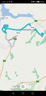
This is what I got on tomtom truck app.

Screenshot_20230803_102803_com.tomtom.gplay.navapp.jpg
 
Sep 17, 2017
5,522
10,321
Birmingham, UK
Funster No
50,575
MH
A-Class
Exp
2017
Thanks for that, sadly though it has directed through a road that is marked as unsuitable for HGV, local knowledge is key when driving a large vehicle but unfortunately, us camper types never like to stay local :LOL:
I just had to check. Technically anything over 3.5t is HGV.

I guess the counter argument is 'unsuitable' doesn't mean banned.
 
Oct 8, 2009
485
353
Kent
Funster No
8,800
MH
Sunlight
Exp
32 years
My route above is from copilot, practical routing, avoid secondary roads and local streets , if possible.
 
OP
OP
Next Stop
Oct 29, 2019
409
1,357
Cornwall
Funster No
66,425
MH
VW LWB Crafter
Exp
Since 2009
I just had to check. Technically anything over 3.5t is HGV.

I guess the counter argument is 'unsuitable' doesn't mean banned.
This is true, from what I've learned whilst playing around with Tomtom and others is that if a road is signed with an actual definite restriction then it will be avoided, otherwise it doesn't seem to care much for road type (A,B,Tertiary, Unclassified) so long as the route is fast or short. The problem is all unclassified roads have a national speed limit so a SATNAV couldn't give two hoots about the width or twistiness as it sees this stretch of road as a quick option.
 
Sep 17, 2017
5,522
10,321
Birmingham, UK
Funster No
50,575
MH
A-Class
Exp
2017
This is true, from what I've learned whilst playing around with Tomtom and others is that if a road is signed with an actual definite restriction then it will be avoided, otherwise it doesn't seem to care much for road type (A,B,Tertiary, Unclassified) so long as the route is fast or short. The problem is all unclassified roads have a national speed limit so a SATNAV couldn't give two hoots about the width or twistiness as it sees this stretch of road as a quick option.
The issue is that it can't discount tiny back roads entirely. There are plenty of camp sites that are at the end of a farm track. If they were effectively removed from its route choices, it wouldn't be able to get you to the destination.

What it needs to do is artificially weight unsuitable roads in its calculations so they have an attached penalty so they're only used if you really need them or it's taking large chunks out of the journey time. But calculating this penalty is really hard. Get it wrong and you end up with odd route choices. There's just not enough data to gauge how difficult country lanes are.
 
OP
OP
Next Stop
Oct 29, 2019
409
1,357
Cornwall
Funster No
66,425
MH
VW LWB Crafter
Exp
Since 2009
My route above is from copilot, practical routing, avoid secondary roads and local streets , if possible.
I really want to love Co-Pilot, as its interface is the best in my opinion (espically in landscape mode on a tablet) and the ability to favour or avoid road type is exactly what a camper/hgv satnav needs, but in practice I have found some real oddball quirks with its choices.

At home it always tries to divert me off the road and down a dirt track and then back on the road if I set it to anything other than a standard car profile, also it really tries desperately hard to avoid our main road for some unknown reason. Also in Netherlands it tried to divert us off a motorway down a service road, luckily common sense took over else we would have had to re-join from the hard shoulder in rush hour.
If these quirks were ironed out I'd be back in a shot!
 
OP
OP
Next Stop
Oct 29, 2019
409
1,357
Cornwall
Funster No
66,425
MH
VW LWB Crafter
Exp
Since 2009
The issue is that it can't discount tiny back roads entirely. There are plenty of camp sites that are at the end of a farm track. If they were effectively removed from its route choices, it wouldn't be able to get you to the destination.

What it needs to do is artificially weight unsuitable roads in its calculations so they have an attached penalty so they're only used if you really need them or it's taking large chunks out of the journey time. But calculating this penalty is really hard. Get it wrong and you end up with odd route choices. There's just not enough data to gauge how difficult country lanes are.
the mapping app OSMAND does a really good job at this, it seems to avoid anything that is marked as 'unclassified' by OSM unless it is absolutely necessary, the problem is it's a bit laggy and isn't that pretty and doesn't have traffic as it's an all in one navigation app for driving, hiking, cycling, skiing etc.
Although it's getting better all the time (y)

Subscribers  do not see these advertisements

 
Apr 27, 2008
11,850
14,089
Eastbourne East Sussex
Funster No
2,327
MH
Hymer low profile
Exp
Since 1972
My current favourites are Copilot, Magic earth and Chinese cheapy. Usually run two of the three at a time (sound off or only on one)
If I don't like the look of a road I just ignore it and let them reroute.
 
Oct 8, 2009
485
353
Kent
Funster No
8,800
MH
Sunlight
Exp
32 years
I was very critical of Copilot some years ago but having had recent problems with Google maps and a TomTom trial, I gave it another go. From here to the nearest city in my car I would take a direct route but with the MH I would avoid it. Copilot set to MH makes the same choice that I would, set to car it takes the direct route.
 
Feb 18, 2017
4,134
8,017
Greenwich, London, UK
Funster No
47,382
MH
Hymer MLT 570
Exp
1986
This is what I got on tomtom truck app.

View attachment 790408
And here is what one section looks like in reality.

OK so there is no grass down the middle, but I think you would struggle to get anything bigger than a PCV down that lane, certainly not a large motorhome or a HGV.

However, legally, there are no restrictions, as far as the mapping software is concerned an HGV can do 60mph down that lane.


1691065321599.png
 
OP
OP
Next Stop
Oct 29, 2019
409
1,357
Cornwall
Funster No
66,425
MH
VW LWB Crafter
Exp
Since 2009
If no actual restrictions are in place then the routing all comes down to road classification, in this example, TomTom treats the road in the photo above with the same classification as West Hill. Clearly, these are two different road types:
TOMTOM.png
1691066678385.png


But OSM however treats it as an 'unclassified road' so it tries to avoid it if feasibly possible:

OSM.png
 
Sep 17, 2017
5,522
10,321
Birmingham, UK
Funster No
50,575
MH
A-Class
Exp
2017
If no actual restrictions are in place then the routing all comes down to road classification, in this example, TomTom treats the road in the photo above with the same classification as West Hill. Clearly, these are two different road types:
View attachment 790484View attachment 790486

But OSM however treats it as an 'unclassified road' so it tries to avoid it if feasibly possible:

View attachment 790481
That's good, but it's using OpenStreetMap, which is very good, but entirely crowdsourced. It is relying on a random spotty geek, who might just be determined to geolocate the post boxes in his town, and correctly labelling the road type is secondary to him. One tiny section of road can be miscoded and your routing could go haywire.

I know because I tried to update OSM when they altered the junction at the bottom of my street to put a bus gate in. After two hours, I gave up.

Subscribers  do not see these advertisements


Join us or log in to post a reply.

To join in you must be a member of MotorhomeFun

Join MotorhomeFun

Join us, it quick and easy!

Log in

Already a member? Log in here.

Latest journal entries

Funsters who are viewing this thread

Back
Top