First job today was to locate some diesel (in Luxembourg) adblue to get rid of annoying warning light and gas.
1.44 for diesel but 1.65 for adblue hurt especially when I turned my nose up at 1.29 the other day.
We tried to do a bit of the mullerthal trail in March but failed and I hadn't done that much research on it.
Stuck mullerthal into the sat nav as no nearby Aires for free and after a couple of detours found a parking spot for motorhomes. Details later.
We decided to walk uphill a bit as downhill looked interesting, then turn round and go downhill after lunch.
Uphill found a couple of quillans which we have worked out to be springs


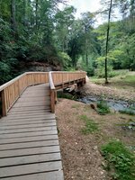
This was extremely flat though you might think it was wheelchair friendly, it was not as they built steps onto the wooden paths and missed an easy ramp allowing all to use the path.
After lunch we did the downhill part to mullerthal. Very picturesque. We noted motorhomes parked at mullerthal but no idea if you paid or could stay.
But we picked up a load of literature about the trailS. There are 3 trails covering 130 Kms. They are not fit for bikes. There are numerous other tributary trails.
Still a pleasant walk at this stage.


Having had a look at the map and thinking other paths would be as easy the C5 was our chosen route as that would meet up with trail 2 to go home. It was only about 10 km round journey. Leaving at 1330 would give us loads of time.
WRONG
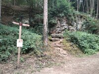
it is like climbing mountains only not constantly just incessantly. Good shoes are required as you walk under the crags with granite steps


Trail 2 separate entry
1.44 for diesel but 1.65 for adblue hurt especially when I turned my nose up at 1.29 the other day.
We tried to do a bit of the mullerthal trail in March but failed and I hadn't done that much research on it.
Stuck mullerthal into the sat nav as no nearby Aires for free and after a couple of detours found a parking spot for motorhomes. Details later.
We decided to walk uphill a bit as downhill looked interesting, then turn round and go downhill after lunch.
Uphill found a couple of quillans which we have worked out to be springs
This was extremely flat though you might think it was wheelchair friendly, it was not as they built steps onto the wooden paths and missed an easy ramp allowing all to use the path.
After lunch we did the downhill part to mullerthal. Very picturesque. We noted motorhomes parked at mullerthal but no idea if you paid or could stay.
But we picked up a load of literature about the trailS. There are 3 trails covering 130 Kms. They are not fit for bikes. There are numerous other tributary trails.
Still a pleasant walk at this stage.
Having had a look at the map and thinking other paths would be as easy the C5 was our chosen route as that would meet up with trail 2 to go home. It was only about 10 km round journey. Leaving at 1330 would give us loads of time.
WRONG
it is like climbing mountains only not constantly just incessantly. Good shoes are required as you walk under the crags with granite steps
Trail 2 separate entry


